– Vijayasekaran Duraisamy
The groundwater pollution is a serious concern worldwide. The geogenic (natural phenomena) and anthropogenic pressures are major reasons for groundwater pollution. However, in arid and semi-arid regions, pollution is mainly aggravated due to anthropogenic activities. It can be further exacerbated in future due to climate change and it’s variability.
The proper monitoring and treatment of contaminants for groundwater are absolute necessary to avoid risks to health, agriculture productivity and environmental degradation. It also calls for giving high priority to its protection and enhancement in the wake of future climate externalities. This blog post highlights the approach that WOTR has undertaken to bridge the gaps in existing water quality monitoring, assessment programmes and its communication with local stakeholders in India. It provides insights from the current study on preparation of groundwater quality index in Upper Godavari River basin, Ahmednagar.
India is the largest consumer of groundwater with average yearly consumption of 230 Km3 (>25% of global total) and 85% share of India’s total drinking water supply is from groundwater (Pahuja et al. 2010). Extraction of groundwater for irrigation supply and domestic use has increased at an alarming rate. The over exploitation and poor management of groundwater has put stress on our groundwater reserves and placed communities at large to an increasing risk of poor groundwater quality. Increasing fertilizer usage, land-use change, excessive pumping and changing rainfall patterns are affecting the quality of both surface and groundwater. It is estimated that almost 50% of India’s river basins are at high risks in physical groundwater quality (Figure.1A). Under the climate change scenario based on representative concentration pathways (RCP) 8.5, the water stress in year 2030 is projected to increase almost 1.4 times in many parts of the country (Figure 1B) However, in national assessments. the importance of groundwater quality is not stressed upon, rather it is more focused on estimating groundwater volumes.

Existing Water Quality Assessments
In India the water quality calculations are mainly carried out via Water Quality Assessment Authority (WQAA) by Central Groundwater Board (CGWB) and Water Quality Monitoring & Surveillance (WQM&S) programme. The WQAA has been constituted in 2001 by Indian government and the yearly assessments are being carried out at a regional scale. For example, in the Maharashtra state, total of 1496 observation wells are in use to monitor groundwater quality at a single time in summer months, (CGWB, 2010). The data collected by CGWB at regional scale is inadequate to make targeted interventions for local scale climate smart adaptation. Also, to make decisions at the local scale the collected information needs to be village specific and required to be effectively communicated with respect to local precautions and measures to improve its quality.
The other country level flagship programme WQM&S on National Rural Drinking Water Programme (NRDWP) was initiated in 2009 by the Ministry of Drinking Water and Sanitation. Under this programme, the quality assessments are made biannually for biological contaminants and annually for chemical contaminants. It has been found that Maharashtra has been affected with Nitrate (18 districts), iron (18 districts), fluoride (18 districts), and salinity (17 districts) based on 2015 assessment. Providing piped water supply is the only remedy for water contamination that was proposed by NRDWP during 16th Lok Shaba standing committee on rural development. However, all these initiatives are not focused on controlling pollution and managing water resources. The Secretary, Ministry of Drinking and Sanitation rightly pointed out that, “The primary reasons of water quality problems include industrial discharge without (or partial) treatment; municipal waste discharge; and use of pesticides/ insecticides on Agricultural land. Whereas primary reasons of quantitative decline of drinking water are high demand of Agriculture; high demand of Industrial needs; and lack of adequate and scientific recharging”. The major source of drinking water in rural areas is from groundwater. So it is absolutely necessary to control and manage the issues of water contamination to provide adequate potable water to habitants. This also means to monitor the changes at finer spatial scales and at regular intervals. Achieving that, is crucial to have “socio-hydrogeological” approach which is the combination of groundwater scientific assessments, capacity building and community participation (Re, 2015).
Case of Mula – Pravara River basin

Understanding the severity of the above issues, Watershed Organisation Trust – Centre for Resilience studies (W – CReS) initiated a research study in Mula – Pravara River basin (4300 Km2) funded by Hindustan Unilever Foundation (HUF). The study is about assessment of groundwater pollution with respect to drinking water quality and irrigational water use. In addition, we are in a process of preparing village level groundwater quality index (GWQI) for the entire basin. Though, this is again an annual affair, but also makes us realize that to address the SDG’s, 3, 6, 13 & 15, we all need to join hands (SDG 17) to reduce the vulnerability and build resilience. Our study has three phases namely, 1.Groundwater quality assessment, 2.Communication of results to various stakeholders to build their resilience, and 3.Dissemination of results via research article and information brief.

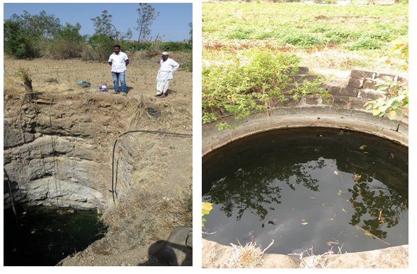
In total 51 sampling locations were identified through systematic sampling with an interval of 10 Kms (Figure.2). Water samples were collected for 3 seasons, Pre-monsoon – 2016 (June), Post-monsoon – 2016 (Sep-Oct), and summer 2017(Mar-April) from gram panchayat open wells and bore wells (Figure.2). The Physico-chemical and biological properties were analyzed with hand-held probe (pH, total dissolved solids, electrical conductivity, salinity) and lab analysis (nitrates, phosphate, total hardness, chloride, sodium, potassium, and total coliforms).

Water quality analyses are completed for 3 seasons based on standard lab procedures outlined by the American Public Health Association (APHA) and the preparation of spatial Ground water Quality Index (GWQI) is in progress. The irrigation water quality is assessed based on sodium absorption ratio, sodium percentage and permeability index. Drinking water quality is assessed with the drinking water standards prescribed by Bureau of Indian Standards (BIS) and World Health Organisation (WHO).

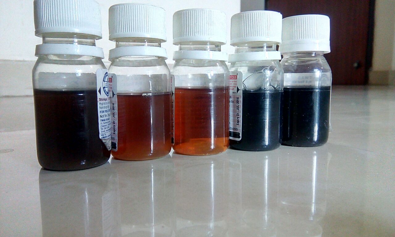
It is has been observed that in many locations, the well parapet walls are not constructed to desired height. During rainfall, the runoff from field loads contaminants and microorganisms easily enter into these wells. Hence, Bacteriological contamination was analyzed in certified accredited lab and in the field by using simple H2S vials to cross-validate and provide on-site evidence to farmers. Almost 90% of the samples turned black in color (unfit for drinking) . To add on, During our first visit to Karshinde village in Sangamner block, a farmer reported that almost 70 people were admitted to the nearest hospital due to ingesting contaminated groundwater (after consumption of contaminated groundwater or due to the ingestion of contaminated groundwater). He also said that,” this is the first time someone has collected water samples to check water quality in their village”. This also highlights the need for local level information, which a regional or short duration study will never address. If people have to make necessary precautions , they need to be provided with information. In another example, in Tharabad village, Rauri block , during water sampling in the post monsoon period, people reported many incidents of typhoid. Based on our initial findings, in both the villages the water quality results indicated the presence of total coliforms greater than -1600 MPN (most probable number) in 100 ml. According to BIS standards, if coliforms are detected in 100 ml of water, it is unfit for drinking. Such reported cases are not restricted to few villages but many villages showed signs of severe contamination after carrying out lab analysis.
In the second phase of this project, the villages identified poor GWQI and the information on the sources of pollution. The same was shared with our Jalsevaks (village water stewards who disseminate and sensitize villagers on the groundwater issues at the community level). Moreover, the field kits like H2S vials and hand-held sensors will be used to inform and take necessary precautionary measures at regular intervals. Though the aim of GWQI is to identify poor quality zones on a basin level, such local exercise will help fill information gaps and build village capacity to take timely decisions where data/information hardly trickles down. Also, for better water resource management of upstream and downstream users of river basin, WOTR is designing experimental games to encourage active community participation.
On a concluding note, adopting the socio-hydrogeology methodology will build capacities of the locals and communicate the scientific assessments with the affected communities. This will help to curb the issues of contamination of ground water and in reviving the quality of it.
References:
Pahuja, S. (2010). Deep Wells and Prudence: Towards Pragmatic Action for Addressing Groundwater Overexploitation in India. Washington D.C. Retrieved from: http://siteresources.worldbank.org/INDIAEXTN/Resources/295583-1268190137195/DeepWellsGroundWaterMarch2010.pdf
Gassert, F., M. Luck, M. Landis, P. Reig, and T. Shiao. 2014. “Aqueduct Global Maps 2.1. Working Paper. Washington, DC: World Resources Institute. Available online at http://wri.org/publication/aqueduct-metadata-global-21.
CENTRAL GROUND WATER BOARD. (2010). Ground Water Quality in Shallow Aquifers of India. FARIDABAD. Retrieved from: http://wqaa.gov.in/WriteReadData/UserFiles/Documents/GW_Quality_in_shallow_aquifers.pdf
Re, V. (2015). Incorporating the social dimension into hydrogeochemical investigations for rural development: the Bir Al-Nas approach for socio-hydrogeology. Hydrogeology Journal, 23(7), 1293–1304. http://doi.org/10.1007/s10040-015-1284-8
Photo credits: Renie Thomas


