By Sarita Chemburkar
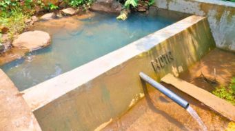
Agriculture is the main source of livelihoods for around 6 out of 10 people in India, and groundwater has played a key role in providing water for agriculture, especially post the Green Revolution in the 1970s. At a global level, India is today the world’s largest groundwater user, consuming an approximately 260 cubic km of groundwater per year, {1} ahead of the United States of America and China. Statistics clearly bring out India’s dependence on groundwater: in 2018, 50 % of drinking water needs in urban India while in rural India 90 % of drinking water and 75 % of agricultural needs are met through groundwater.[2]
Within India, Maharashtra is one of the states that depends heavily on groundwater. Drinking water needs of around 80 percent of the state’s rural population are met through groundwater, while 71 percent of the agricultural land is irrigated through groundwater. [3] Thanks to the increasing population and erratic rainfall patterns, the pressure on groundwater in Maharashtra has only been intensifying. As a consequence, Maharashtra is now going through a major groundwater crisis. A total of 71 percent of talukas in Maharashtra–252 out of the total 353–witnessed 1 metre depletion in groundwater levels in the past 5 years.[4] It is seen that 57% of wells in Maharashtra have recorded a decline in groundwater level in the last 10 years, according to a study by the Central Ground Water Board (CGWB). [5]
Groundwater – public or private property?
One of the major causes for this crisis in groundwater, is that while water in ponds or lakes can be seen on the surface, when it comes to groundwater farmers often have no idea how much water is available below the surface as it is not visible to the naked eye. They cannot easily visualize the water which is available below the surface. Increasing demand for groundwater has led to unscientific exploitation leading to water stress. To worsen matters, village residents tend to think that water present below their lands is their private property.
It is pertinent to note in this context, that much of Maharashtra is covered with hard rock, which has primarily low porosity and low permeability of water. This is coupled with high temperatures in semi-arid zones of Maharashtra, such as the villages of Bhokardan taluka of Jalna district and Sangamner and Akole blocks of Ahmednagar district, where water storage can only happen below the ground level as the amount of evaporation of surface water is high. Thus, storing water underground minimizes evaporation and also ensures water security. All this, however, requires effective water management at local levels.
In order to facilitate this, WOTR has come up with a participatory 3D modelling tool called CoDriVE – Visual Integrator (Co-DriVE-VI).
What is Co-DriVE-VI?
This tool helps enhance participants’ understanding and their knowledge regarding the available water resources by demystifying the science of hydrology. They can visualize and relate their village topography with the subsurface and understand the groundwater scenario. It also aids them to understand the groundwater potential zones and its recharge mechanism through different rocks that are present below their village surface. CDVI helps villagers’ visualize above ground features as well as subsurface aquifers that contain groundwater.

WOTR facilitator Sarita Chemburkar explaining the concept of P3DM to villagers from Mendhawan, Shivapur and Kasare villages of Ahmednagar district. Photo: Ankita Yadav
3-D aquifer mapping
From July 2017, WOTR with the support of Oracle has conducted seven aquifer management stakeholder engagement workshops in 10 villages of Ahmednagar and Jalna districts of Maharashtra. The subsurface model is created based on the two dimensional subsurface map that is generated in ArcGIS with geophysical data that is processed using a particular software. (ArcGIS is a systems to work with maps and geographical information.) The method through which this data is generated is through the geophysical method, or the vertical electrical sounding method. This provides valuable information regarding the vertical succession of rock that are present below the surface; through this, we can determine aquifer thickness. Based on the lithology or the physical characteristics of the rocks, we can identify the potential zones of groundwater.
With the help of this 3D model, the rural communities get a clear picture of their subsurface (aquifers) based on which they can carry out water budgeting. WOTR has also planned aquifer level workshops for the youth, including school students. The 3D model helps the community identify common aquifers that lie below their village surface and helps them realize that it is a common property. This shows them the need for the community to come together and formulate rules and regulations to manage water.
How is the Co-DriVE-VI 3D model made by the local community?
During stakeholder engagement aquifer workshops, participants were encouraged to take part and prepare a 3D model of their own villages. Initially, they had no idea what to do and needed a lot of guidance. After WOTR’s facilitators explained the steps, the participants started working on the unsorted corrugated cardboard that were placed in front of them. They discussed among themselves how best to demarcate the topographical features such as forest area, streams, wells and roads. These features were shown on the model with the help of different colors.
After they prepared the models, they could visualize their entire village, which they had never seen in a 3D format before. All of them were amazed to see their village in this format. One participant even said, “We never thought of anything like this. We can see each and every part of our village, especially the number of bore wells and the dug wells, in this model. It has created a new-found awareness about groundwater and the need to use it properly.”


Pictures of villagers from Mendhawan, Shivapur and Kasare villages taking part in the P3DM exercises held at WOTR’s Darewadi Learning Centre, Darewadi in Ahmednagar. Photo: Ankita Yadav
In conclusion, our observation has been that CDVI is very useful in reducing exploitation of available water resources and help communities’ combat drought. This tool is a game changer for the villagers as our current experiences with 3D visualization has been that it has a tremendous impact on ordinary participants and gives them valuable insights in protecting and managing their water resources at a local level.
(Edited by Vikas Prakash Joshi)
References
- https://qz.com/india/1298108/india-must-treat-groundwater-as-a-common-resource-not-private-property/
- Ibid
- https://www.indiawaterportal.org/articles/maharashtra-groundwater-development-and-management-act-2009
- https://bit.ly/2AEvlBv
- http://www.asianage.com/metros/mumbai/220318/57-per-cent-of-maharashtra-wells-show-decline-in-groundwater.html