by Ajit Jadhav
Global warming has been affecting human lives worldwide, but this is occurring more rapidly in recent years due to various human activities. The earth’s temperature has increased by 1.5 degrees, leading to change in weather conditions and subsequently affecting the amount of rainfall in a year (Gao, Y., Gao, X., & Zhang, X., 2017). The fall and rise in the amount of rain directly impact the land use and land cover of that area and also the land surface temperature (LST). Alteration in the land use and land covers results in an increase in fallow land and wasteland of that area which may reduce the agricultural production. On the other hand, the rise in surface temperature of the land is one of the key factors which can lead to drought-like conditions, increase in soil erosion, heat waves, sea-level rise, etc. All these calamities lead to exacerbating many challenges faced by humans in day to day life.
Bhokardan block is located in the Jalna district of Maharashtra. The area of Bhokardan extends from the latitude 20.025401 N to 20.559834 N and longitude 75.586614 E to 75.973938 E. The river Purna passes through some parts of Bhokardan, and the average rainfall of this area varies from 650mm to 750mm. Bhokardan starts experiencing the increasing heat from the last week of April and remains till the first week of June. In the month of May, the temperature increases above 41 degree Celsius which sometimes results in heatwaves.

WOTR – Centre for Resilience Studies (W-CReS) conducted a research study to understand the impact of land use and land cover changes on the land surface temperature. LANSAT TM and LANDSAT ETM satellite data of May 2001, 2011 and 2020 was used to map various land use and land cover classes. The spatial resolution of the LANDSAT satellite data is 30m.
The LST data is collected using MODIS for May 2001, 2011 and 2020 with a resolution of 1km. MODIS or Moderate Resolution Imaging Spectroradiometer is a sensor onboard Terra and Aqua platform that provides information about the earth surface in wavebands covering the visible, near-infrared, short wave infrared and thermal ranges. The month of May has been selected for LST data analysis because the summer temperature is highest in this month in the Bhokardan block.
To prepare the LULC maps of Bhokardan block, a supervised method of image classification has been used for 2001, 2011 and 2020. The classification scheme adopted in the study includes 9 LULC categories- irrigated land, fallow land, scrubland, plantation, forest, wasteland, settlement, dry river bed and waterbody.
MODIS LST data come in two variants, i.e. LST for day and LST for a night, and the calculation of day and night LST data also has been done for the month of May for the above mentioned years. The data has been sub-set to study area and has also been re-projected from Sinusoidal projection to the UTM Zone 43 N projection system with WGS-84 datum.
For analysis, the land use and land cover (LULC) classification has been done for all the selected decadal years and then the LST images of the same years has been overlaid on the LULC data. To analyze the LST variation for various LULC classes, a linear profile of LST is prepared using three lines, i.e., AB, CD and EF, as shown in figure 5, 6 and 7. These lines represent the variation in decadal LST according to the LULC changes in the same area.
From the results obtained, it has been observed that the LULC changes affect the LST of the local, regional and global climate process.

Fig. 2 represents the decadal LULC changes, which clearly indicates the irrigated land is more in 2011 compared to 2001 and 2020. In 2001, a significant amount of the wasteland is converted into irrigated and fallow land. Every decade, there is an increase in fallow land as the farmers only took the Kharif and Rabi season for crop cultivation.

Fig. 3 shows the decadal variations in land surface temperature for daytime, ranging from 40°C to above 50°C. In comparison to all the decadal year, 2011 has the lowest temperature because of higher irrigated land and on the other hand, the land surface temperature of the years 2001 and 2020 is higher than that of 2011 and above 50 °C.

Fig. 4: Decadal variation in May Month Land Surface Temperature-Night (°C) of Bhokardan
Fig. 4 shows decadal variations in land surface temperature for night time, some patches of 2001 and 2020 having the temperature above 28°C, whereas, in 2011, the maximum temperature went up to 27°C. This indicates that 2001 and 2020 were hotter than 2011, even during night times.
Land Surface Temperature of Bhokardan


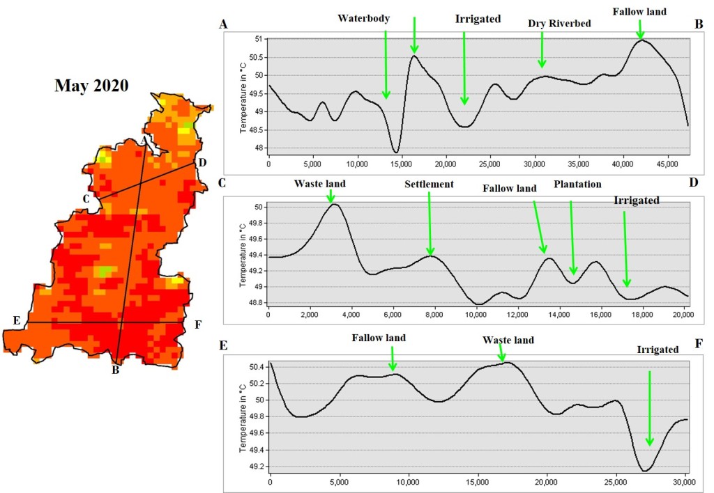
Fig. 5, 6 and 7 show a profile of LULC classes as a line graph of varying land surface temperature. In all the profile graphs, the areas with higher land surface temperature fall under wasteland, fallow land, dry river bed, scrubland, and settlement categories, whereas the areas with lower land surface temperature are falling under irrigated land waterbody, plantation and forest categories.
This analysis suggests that even in summertime, the land surface temperature remains at the lower side in vegetation/tree canopy covered areas, while it goes to highest in the open lands such as wasteland, barren rocky areas, etc. In climate change, the future pattern of land use and land cover will affect human communities and ecosystems. This may influence how and where human lives and use the land for various purpose.
The following conclusion can be drawn from the study:-
- Low vegetation cover in the rural area is the responsible factor for the unusual pre-monsoon summer day heat islands.
- The region, specifically fallow and barren/wastelands, is seasonally converted from croplands with higher LST during the summer months in the study area.
- Higher LST in plain barren regions during summer days results in intensified heatwaves in the rural areas
- The changing LULC patterns in rural areas may be one reason associated with higher occurrences of heatwaves and health impacts related to heat stress in the local area.
- Monitoring this area with changing land use and land cover patterns can help provide early steps for adapting suitable policies to either overcome or minimize the heat stress problems.
References
Govil, H., Guha, S., Dey, A., & Gill, N. (2019). Seasonal evaluation of downscaled land surface temperature: A case study in a humid tropical city. Heliyon, 5(6), e01923.
Gao, Y., Gao, X., & Zhang, X. (2017). The 2 C global temperature target and the evolution of the long-term goal of addressing climate change—from the United Nations framework convention on climate change to the Paris agreement. Engineering, 3(2), 272-278.
Khandelwal, S., Goyal, R., Kaul, N., & Mathew, A. (2018). Assessment of land surface temperature variation due to change in elevation of area surrounding Jaipur, India. The Egyptian Journal of Remote Sensing and Space Science, 21(1), 87-94.
Jiang, J., & Tian, G. (2010). Analysis of the impact of land use/land cover change on land surface temperature with remote sensing. Procedia environmental sciences, 2, 571-575.